

Glossary
A - C D - F G - I J - L M - O P - R S - U V - Z
Abandoned Well: a well whose use has been permanently discontinued, or a well which is in such disrepair that its continued use for the purpose of obtaining groundwater is impractical or may be a health hazard. Such wells can be a direct "pipeline" for introducing contamination into the groundwater.
Aquiclude: A geologic formation which may contain water but does not transmit it.
Aquifer/Aquifer System: A water-bearing layer(formation) of rock or sediment capable of yielding sufficient, economical quantities of water to wells. Typically is unconsolidated deposits or sandstone or limestone.
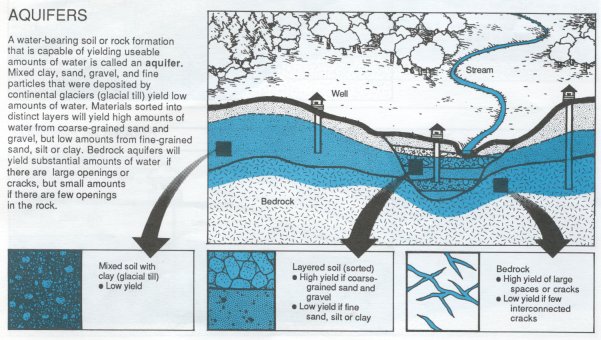
Image Source: Michigan State University Extension, Water Quality Bulletin # 35, August 1991
Aquitard: A saturated but poorly permeable formation that does not yield water freely to a well or a spring. However, an aquitard may transmit appreciable water to or from adjacent aquifers.
Area of influence: Area surrounding a pumping or recharging well within which the water table or potentiometric surface has been changed due to the well's pumping or recharge.
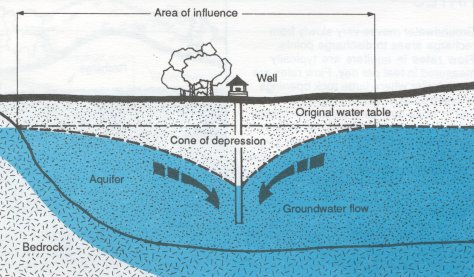
Image Source: Michigan State University Extension, Water Quality Bulletin # 35, August 1991
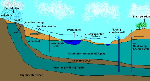
Artesian Conditions: In a confined aquifer, when the water level in a well rises above the top of the aquifer.
Best Management Practices (BMPs): structural, nonstructural, and managerial techniques recognized to be the most effective and practical means to reduce surface water and groundwater contamination while still allowing the productive use of resources.
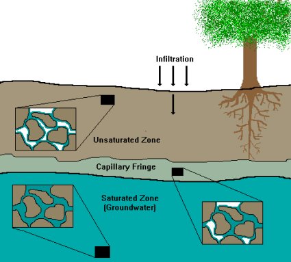
Capillary Fringe: a zone in the soil just above the water table that remains saturated or almost saturated, because the water is drawn up against the force of gravity due to waters adhesive and cohesive forces (capillary action).
Cone of depression: A depression in the groundwater table or potentiometric surface that has the shape of an inverted cone and develops around a well from which water is being withdrawn. The slopes of the cone become increasingly steep the closer they are to the well. Its trace (perimeter) on the land surface defines the zone of influence of a well. Also called cone of drawdown.
Image Source: Michigan State University Extension, Water Quality Bulletin # 35, August 1991
Confined aquifer: Aquifers that are wedged between layers of relatively impermeable materials and are consequently under pressure. Also know as an artesian aquifer.

Image Source: Michigan State University Extension, Water Quality Bulletin # 35, August 1991
Confining Layer: geological material through which significant quantities of water can not move; located below unconfined aquifers, above and below confined aquifers. Also known as a confining bed.
Contaminant: An undesirable substance (physical, chemical, biological, or radiological) not normally present, or an unusually high concentration of a naturally occurring substance, in water, soil, or other environmental medium.
Drawdown: The vertical distance groundwater elevation is lowered, due to the removal of groundwater. The distance between the static water level and the surface of the cone of depression.
Flowing Artesian Well: When the top of a well in a confined aquifer is below the potentiometric surface, water will flow out of the well under pressure.
Groundwater: Water occurring in the zone of saturation in an aquifer or soil. Water beneath the surface of the earth which saturates the pores and fractures of sand, gravel, and rock formations.
Groundwater barrier: Rock or artificial material with a relatively low permeability that occurs (or is placed) below ground surface, where it impedes the movement of groundwater and thus may cause a pronounced difference in the heads on opposite sides of the barrier. Also called a confining layer.
Head: Height of the column of water at a given point in a groundwater system above a datum plane such as mean sea level. It is also a measure of pressure as in a confined aquifer where the elevation of the groundwater does not equal its head because it is under pressure.
Hydraulic Conductivity (K): A coefficient of proportionality describing the rate at which water can move through a permeable medium. It is a function of the porous medium and the fluid. The rate of flow of water in gallons per day through a cross-section of one square foot under a unit hydraulic gradient (gpd/ft²), at the prevailing temperature. See permeability.
Hydraulic Cycle: The continuous circulation of water between the earth and the atmosphere, through condensation, precipitation, runoff, percolation, evaporation, transpiration, groundwater storage and seepage, and re-evaporation into the atmosphere.
Hydraulic Gradient (i): Slope of a water table or potentiometric surface. Groundwater flows from points of high elevation and pressure to points of low elevation and pressure. The difference in hydraulic head divided by the distance along the flowpath.
Impermeable: Characteristic of geologic materials that limit their ability to transmit significant quantities of water under the head differences normally found in the subsurface environment.
Leaking Underground Storage Tank (LUST): An underground tank which has a structural rupture and its contents are leaving their containment and entering the surrounding environment.
Nonpoint source: Pollution of the water from numerous widespread locations that are hard to identify and pin-point. Ex. agri-chemicals through leaching or runoff or any conveyance not meeting the definition of point source.
Perched Aquifer: An aquifer containing unconfined (unpressurized) groundwater held above a lower body of groundwater by an unsaturated zone; often a result of clay lenses in the soil strata.
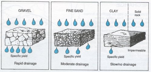
Permeability: Capacity of a rock or soil material to transmit a fluid.
Piezometric surface: See potentiometric surface.
Image Source: Michigan State University Extension, Water Quality Bulletin # 35, August 1991
Point source: Pollution of water from one place in a concentrated manner that is easy to identify. Ex. leaking underground storage tank, discharge pipe from a sewage treatment plant, any pipe, ditch, channel, tunnel, conduit, well, discrete fissure, container, rolling stock, animal feeding operation, or landfill, from which pollutants are or may be discharged.
Pollution Plume: an area of a stream or aquifer containing degraded water resulting from migration of a pollutant. It extends from the source of contamination to another point in the direction of the water flow.
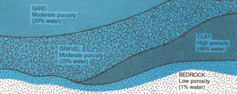
Porosity: The capacity of soil or rock to hold water. The ratio of the volume of void spaces in a rock or sediment to the total volume of the rock or sediment.
Potable water: Suitable for human consumption as drinking water.
Potentiometric Surface: An imaginary surface formed by measuring the level to which water will rise in wells of a particular aquifer. For an unconfined aquifer the potentiometric surface is the water table; for a confined aquifer it is the static level of water in the wells. (Also known as the piezometric surface.)
Image Source: Michigan State University Extension, Water Quality Bulletin # 35, August 1991
Public Water System (PWS) (EPA): Any water system providing water for human consumption for an average of at least 25 persons per day (or 15 or more service connections) and in use for at least 60 days each year. Further defined as follows:
- Community Water System: A Public Water System which serves at least 15 services connections used by year-round residents or regularly serves at least 25 year-round residents.
- Transient, Non-Community Water Systems: A Public Water System that is not a community water system. These systems do not regularly serve at least 25 of the same persons over six months per year.
- Non-Transient, Non-Community Water System: A Public Water System that is not a community water system and that regularly serves at least 25 of the same persons over 6 months per year.
Recharge area: Area of land allowing water to pass through it into an aquifer by surface infiltration. This process occurs naturally when rainfall filters down through the soil or rock into an aquifer, usually in the higher gradient section overlying the aquifer.
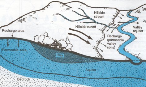
Image Source: Michigan State University Extension, Water Quality Bulletin # 35, August 1991
Static Water Level: The level of water in a well that is not being pumped. (The drawdown has been recharged by the surrounding groundwater.)
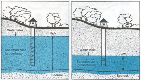
Saturated Zone: The portion of subsurface soil and rock where every available space is filled with water. Aquifers are located in this zone.
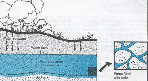
Image Source: Michigan State University Extension, Water Quality Bulletin # 35, August 1991
Time of Travel (TOT): The time required for a particle of water to move in the saturated zone from a specific point to a well. A line can be drawn around the area for which groundwater is expected to reach the well within a chosen period.
Transmissivity: A measure of the ability of an aquifer to transmit water. The rate at which water is transmitted through a unit width of an aquifer under a unit hydraulic gradient. Transmissivity values are typically given in gallons per day through a vertical section of an aquifer one foot wide and extending the full saturated height of an aquifer under a hydraulic gradient of 1 (gpd/ft).
Unconfined Aquifer: An aquifer which the water table is its upper boundary. Because the aquifer is not under pressure the water level in a well is the same as the water table outside the well. An unconfined aquifer is near to the earth's surface causing it to be easily recharged as well as contaminated.
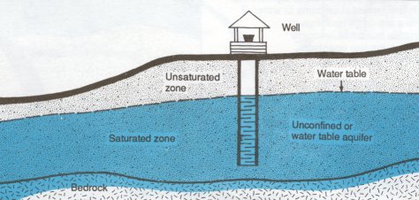
Image Source: Michigan State University Extension, Water Quality Bulletin # 35, August 1991
Underground Storage Tank (UST): a tank system, including its piping, that has at least 10% of its volume underground
Unsaturated Zone: An area, usually between the land surface and the water table, where the openings or pores in the soil contain both air and water. Also called the zone of aeration.
Image Source: Michigan State University Extension, Water Quality Bulletin # 35, August 1991
Watershed: All the land area and water within the confines of a drainage divide in which all surface runoff will drain through one point, such as a stream or river. Determined by topographic high points.
Water Table: The water level of an unconfined aquifer, below which the pore spaces are saturated. The water table depth fluctuates with climate conditions on the land surface above and is usually gently curved and follows a subdued version of the land surface topography.
Image Source: Michigan State University Extension, Water Quality Bulletin # 35, August 1991
Well: An opening in the surface of the earth for the purpose of removing fresh water.
Well field: An area containing two or more wells supplying a public water supply system.
Wellhead: The physical structure, facility, or device at the land surface from or through which groundwater flows or is pumped from subsurface, water-bearing formations.
Wellhead Protection Area (WHPA): A geographically designated surface and subsurface area surrounding a water well or wellfield, supplying a Public Water System, through which contaminants are reasonably likely to move toward and reach such water well or well field. This is an area where groundwater protection is emphasized. A WHPA includes at least the delineated capture zone area, but could be influenced by other factors such as existing land use and zoning, site and facility identification and location, political boundaries, natural features, and environmentally sensitive areas.
Wellhead Protection Program (WHPP): A program to protect public water supply systems from potential sources of groundwater contamination.
Zone of Contribution (ZOC): The area surrounding a well that encompasses all areas and features that supply groundwater to the well.
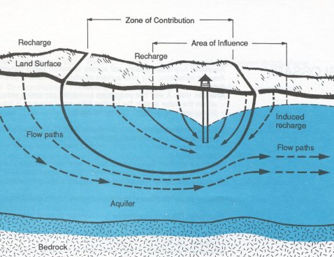
Image Source: Michigan State University Extension, Water Quality Bulletin # 35, August 1991
Zone of Influence (ZOI): The area of groundwater which is affected by the pumping of a well. The faster the pumping rate the larger the area. The area of land above the cone of depression.
Image Source: Michigan State University Extension, Water Quality Bulletin # 35, August 1991
Zone of Transport (ZOT): The area that contains the groundwater that will reach the well within a specified time. Similar to time of travel.